Donald Trump today referred to Puerto Rico as “an island in the middle of the ocean.”
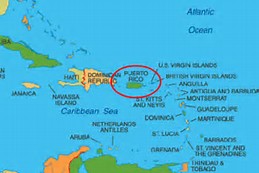
I won’t spend a lick of time criticizing the president of the United States over his lack of understanding of where this U.S. territory is located. I do, though, want to call attention to the map I’ve posted here.
Puerto Rico is inside the red circle. It sits on the edge of the Caribbean Sea. To its west is Hispaniola, which comprises the Dominican Republic and Haiti; to its east are the U.S. and British Virgin Islands.
The president’s description of Puerto Rico’s location is meant to highlight the difficulty, apparently, of getting relief supplies to that stricken island. Hurricane Maria battered the island savagely two weeks ago. The entire island is without electricity. It lacks potable water. Its 3.5 million residents — all of whom are U.S. citizens — are suffering terribly.
It’s not in the “middle of the ocean.”

As a liberal I am sure you try to find every opportunity to criticize the president. Let me give you a few basic facts. San Juan PR is over 1000 miles from Miami FL the closest major port to the USA. San Juan is over 1600 miles from NYC one of the northern major ports in USA. The Atlantic ocean is approx. 3000 miles in width give or take a few hundred miles depending on where you measure it. I’ll do the math for you. The middle of the Atlantic is 1500 or so miles from the mainland. I suggest you and your liberal friends do the math and try again.
Samoa is “in the middle of the ocean.” So is Hawaii. Guam, too. I know where PR is in relation to Miami. But my definition of “middle of the ocean” doesn’t seem to fit PR’s proximity to, say, Hispaniola and Cuba. But … thanks for your comment. And, yes, I am a severe critic of the president.
Those are both islands in the Atlantic you named. Being islands themselves means the edge of the ocean does not begin at the coast of Hispaniola or Cuba. And in practical terms your examples mean even less in the effort to get relief from US ports to Puerto Rico.