Tag Archives: USGS

‘Vancouver, Vancouver … this is it!’

When you grow up in a part of the world full of natural beauty highlighted by snowcapped peaks all along your eastern horizon, you take for granted that they’ll always be there … as in always.

Forty years ago today, that notion changed for those of us who lived west of the Cascade Range, a long string of volcanic peaks stretching from British Columbia to Northern California.

Mount St. Helens blew apart on May 18, 1980. I was at home in Portland, Ore., about 50 miles south-southwest of the peak. We couldn’t watch the event occur in real time, as the sky was overcast that Sunday morning (yes, imagine that, if you can). But oh brother, we knew about it.

There are things in life you really don’t expect to witness or experience up close. An erupting volcano, to be honest, was not on my list of life experiences. However, that day it damn sure did etch itself into my memory.

The peak began rumbling to life in March. The ground beneath the then-9,677-foot summit in southwest Washington was quaking regularly. The peak began collapsing as craters formed atop the pristine summit of Mount St. Helens. I was editor of a small daily newspaper in Oregon City. We felt compelled to cover the story as it was developing. One of our reporters, David Peters, drove to near the peak with his fiancée to visit with a young man assigned by the U.S. Geological Survey to study Mount St. Helens’ evolution from dormant to active volcano.

The young man was David Johnston. He gave Dave Peters a statement that proved hauntingly prophetic, which was that if the mountain were to blow up then and there, they all would be killed. Happily for my friends, it didn’t. They returned home and Dave wrote a wonderful story for the newspaper.

I had another thrill, flying in a single-engine airplane over the summit that day as the mountain was quaking and shuddering. Only after we returned to my acquaintance’s hangar in Mulino, Ore., did I learn that federal aviation officials clamped a no-fly restriction for miles around the summit. They didn’t bust us, for which I will be grateful.

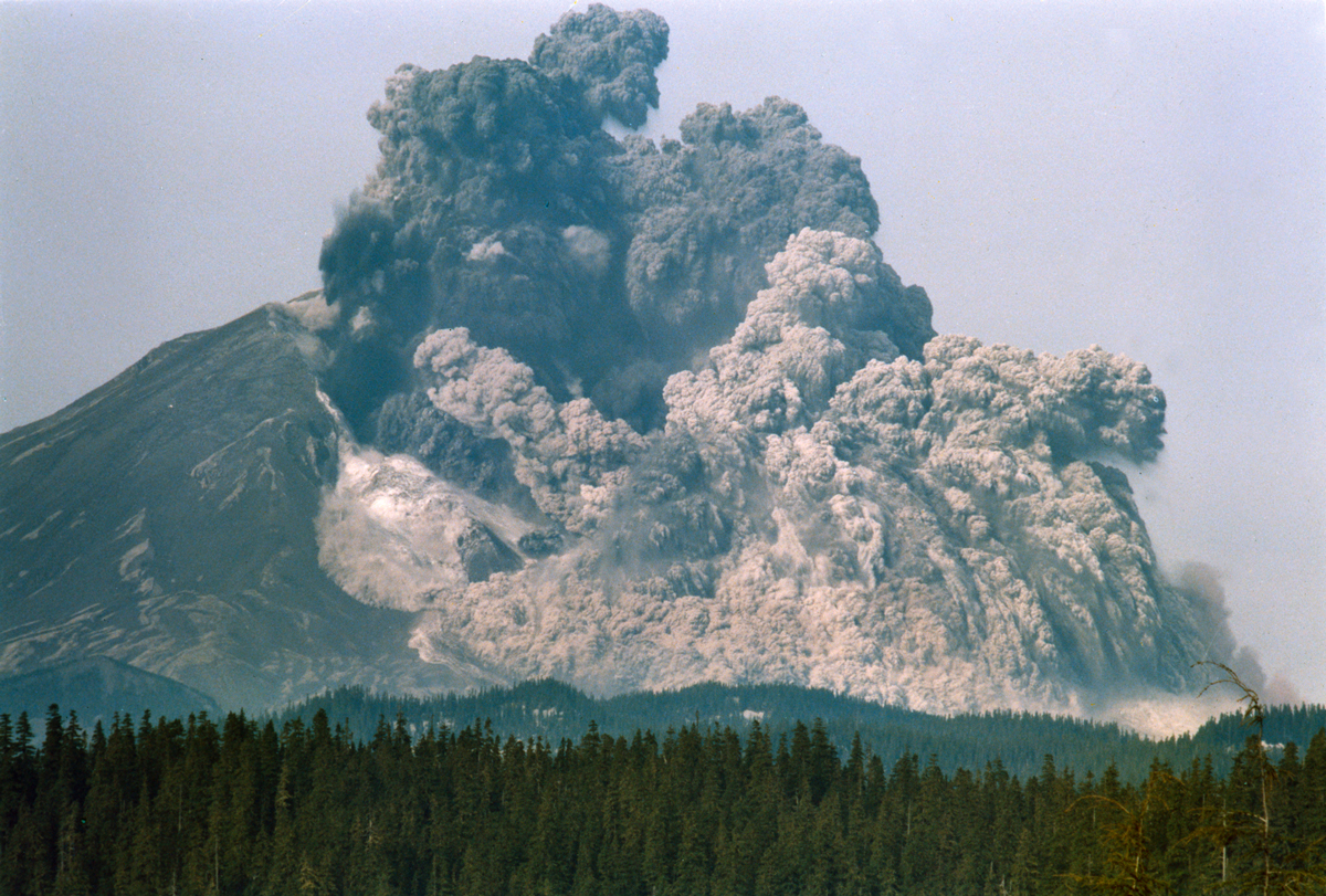
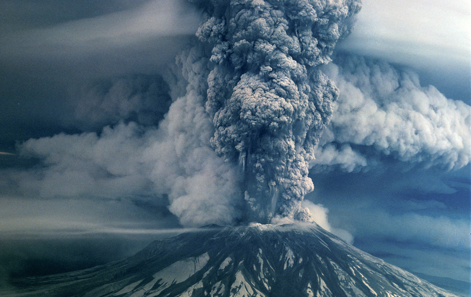
Then came the blast that changed the history of the Pacific Northwest. The mountain’s north face slid away from a huge earthquake, releasing an torrent of ash, fiery gas and rock. Thousands of acres of virgin timber were destroyed. Spirit Lake filled with logs and all manner of volcanic debris.

David Johnston radioed immediately to his USGS headquarters, “Vancouver, Vancouver … this is it!” 

Then he was gone. The pyroclastic flow from the beastly mountain incinerated the young volcanologist in an instant.

Oh, man. The memory of it all.

Time of My Life, Part 4: Staring down a volcano

I long have been proud to say that my career allowed me to do things that most folks don’t get to do . . . such as fly over an erupting volcano!

But in late March 1980, I had that singular honor thrust on me.

You’ve heard of the cataclysm that occurred on May 18, 1980 when Mount St. Helens exploded, wiping roughly 1,400 feet off dirt, ash and rock off its summit. It killed about 65 individuals and wiped out Spirit Lake, Wash., and thousands of acres of virgin timberland.

What you might not recall is that the eruption began two months earlier.

I was editor of the Oregon City (Ore.) Enterprise-Courier at the time. I had written a feature story about a father and son in Clackamas County who restored vintage aircraft; the son gave me a ride in a biplane, which was a thrill in itself.

I got back to the office and a day or two later we got word of Mount St. Helens rumbling; the earth was trembling under the mountain. The U.S. Geological Survey sent teams to the region to monitor the quakes. The USGS then determined quickly that the mountain was entering a pre-eruptive phase. It could blow at any minute.

I called my young friend who gave me the biplane ride and said something like this: “If Mount St. Helens starts to erupt, can I call on you to fly me to the mountain to take pictures?” He agreed.

Then came the pre-cataclysm. St. Helens began to “erupt,” meaning that the quakes began creating craters along the summit. I called my friend. I drove out to his airfield. We boarded a two-seat single-engine prop airplane and took off. In the meantime, a colleague of mine at the newspaper, David Peters, drove about 75 miles to the USGS station near the foot of Mount St. Helens, where he would interview a young man who became a legendary figure in the Pacific Northwest; more on him in a moment.

My pilot friend and I arrived at the mountain and buzzed the summit repeatedly. I threw open the window on the passengers side of the plane and snapped hundreds of pictures of the summit as ice and snow began caving into newly created craters on top of the 9,600-foot peak.

Now, full disclosure time: The plane had no working radio. We were unable to hear any warnings from the FAA or the USGS about the “stunt” we were pulling off in the moment. I would learn upon returning to the airfield that the FAA had placed a no-fly zone around the summit. We were unaware. The statute of limitations ran out long ago, so I won’t be prosecuted for this admission.

As for Dave Peters’s assignment, he interviewed a USGS volcanologist by the name of David Johnston. On May 18, 1980, it was Johnston who radioed to his headquarters in Vancouver, Wash., from a ridge north of the mountain as the peak exploded.

He yelled: Vancouver, Vancouver. This is it! The pyroclastic flow of white-hot ash and rock that sped across the ridge vaporized Johnston in an instant. He was gone. The spot where he told the world of what was occurring now carries the name Johnston Ridge.

I was enabled because of the work I did to have more fun in pursuit of that job than I really deserved. That event in March 1980 pretty much tops the list of unique experiences.

I caught my breath. We published some pictures in the newspaper. Dave Peters wrote a wonderful feature on Johnston.

My wife shared with me the thrilling experience I had on that fateful day. I told Mom and Dad about it the next day.

They, um, were not pleased.

Some things you think you'd never see

helens_page06_15

When I was growing up, if anyone ever thought to ask me if there was something I’d like to witness but would never get the chance, I might have said “a volcanic eruption.”

I grew up in Portland, Ore., about 50 or so miles west of a chain of volcanic peaks along the Cascade Range. Most of the peaks were considered to be in various stages of dormancy. Some of them are extinct. They’ll never erupt again.

One of them, though, just northeast of our city, was considered “most likely” to erupt. Who would have thought we’d actually witness it.

Thirty-five years ago, on May 18, 1980, good ol’ Mount St. Helens blew apart in a cataclysmic blast no one likely ever thought they’d witness.

It was a Sunday. It was overcast in Portland that morning, so we didn’t actually witness the ash cloud blown 50,000 feet into the air over Washington state. Aerial photographers took plenty of pictures, though. It was a huge day in the lives of those of us who grew up looking eastward along the Cascades.

Portland’s signature actually is Mount Hood, the highest peak in Oregon. To the north of Mount Hood is Mount St. Helens.

Prior to the blast, Mount St. Helens cut an impressive and pristine figure against the sky. It looked almost geometrically perfect. Some folks called it the “Mount Fuji of the Americas,” as it bore some vague resemblance to Japan’s famous — and perfectly shaped — peak.

The cataclysm took care of Mount St. Helens’s appearance. It blew about 1,500 feet of dirt and rock off the top of the mountain, scattering it as part of that pyroclastic flow of hot gas and ash that ripped through the Douglas fir forest, filling Spirit Lake with fallen timber.

The mountain had been rumbling for a couple of months prior to the blast. I had the thrill of a lifetime when I flew over the summit in a private aircraft to take pictures of the crater’s early beginning. One of my colleagues at the paper where I worked drove that day in March to interview individuals who were monitoring the mountain’s activity for the U.S. Geological Service.

My colleague, Dave Peters, caught up with a young geologist named David Johnston, visited with him about what he was witnessing as the mountain started rumbling. Dave returned and filed a fascinating feature about Johnston and others he met that day.

Johnston would die in the blast a few weeks later as he was perched on a ridge that would be renamed in his memory. As the once-gorgeous peak blew apart, Johnston yelled into his radio to the USGS headquarters: Vancouver, Vancouver … this is it!

And then, just like that, he was gone.

That amazing day is etched in the memories of those of us who were aware of the volcanoes that dotted our skyline to our east.

I doubt any of us ever thought we’d witness what we saw on that Sunday morning 35 years ago.

Who knew?

When a pristine peak blew its top

https://www.youtube.com/watch?v=xP2dreOI8gI

Admit it. You’ve thought at least once in your life that there are things in this world you thought you’d never see, certainly not up close.

I’ve had a few of those thoughts in my life. But if you live long enough and are fortunate travel and see a few places around the world, you get to check many of those things off your “bucket list.”

I never thought I’d ever witness a volcano explode, even though I grew up in a part of the country — the Pacific Northwest — that features a range of mountains, the Cascades, that includes a string of dormant and extinct volcanos stretching from British Columbia to northern California.

On May 18, 1980, that all changed.

Mount St. Helens, a once-pristine peak that sits about 60 or so miles northeast of my hometown of Portland, Ore., erupted in a massive cloud of gas, ash, rock and magma. The prevailing wind took the massive cloud northeast over the Yakima Valley, Spokane, the Idaho Panhandle and over much of Montana.

The world had been following this story for months prior to the explosive moment. The U.S. Geological Service had sent a team of scientists to study the earthquakes that had been rumbling under the peak since February 1980. Washington Gov. Dixie Lee Ray had issued warnings to residents around the base of the peak to get out. Most of them did.

One who didn’t leave was a crusty old fellow named Harry Truman. “I ain’t goin’,” he’d say, or words to that effect. He and his cats stayed put and were buried under several hundred feet of volcanic mud.

It was a Sunday morning when the mountain blew. We didn’t see it actually explode from our house in Portland, as it was overcast that day … imagine that, eh? But it erupted and blew roughly 1,500 feet off the summit of what used to be a nearly perfect cone-shaped peak, one of several that dominates the horizon north and east of Portland.

We would see subsequent eruptions later that summer. One, in July, sent an ash cloud actually higher into the air that the May 18, 1980 cataclysmic blast. The mountain has experienced minor eruptive episodes in the years since and I believe the USGS still classifies St. Helens as an active volcano.

Arguably the most memorable quote of that remarkable moment came from a USGS scientist, who, when the mountain blew was perched on a ridge across Spirit Lake. David Johnston had been monitoring the mountain for weeks, reading seismic equipment and feeding data back to his headquarters in nearby Vancouver, Wash., just across the Columbia River from Portland.

Then the blast occurred, prompting Johnston to exclaim: “Vancouver, Vancouver, this is it!”

Then, in an instant, David Johnston was vaporized.

The rest of us remember the event well.